Geomorphometry is the quantitative description and measurement of topography and landforms. In geomorphometry, mathematical and statistical processing techniques are employed to quantify aspects of the land surface in order to improve mapping and modelling of formative geological processes.
In comparison to subaerial and planetary landscapes, submarine environments are rarely investigated using quantitative geomorphological techniques. Application of traditional geomorphometric techniques is hindered by the spatial variability in bathymetric data resolution and the extensive scale over which changes in topography occur.
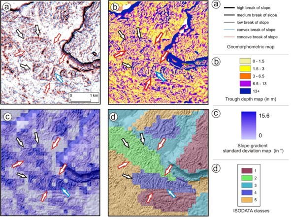
In this project we proposed a novel methodology for the improved quantitative analysis of submarine elevation data by adapting numerical techniques, developed for subaerial analyses, to submarine environments. The method integrates three main morphometric techniques: (1) moment statistics and their statistical analyses, (2) feature-based quantitative representation, and (3) automated topographic classification. These techniques allow useful morphological information to be extracted from a digital elevation model. Morphometric attributes and their statistical analysis provide summary information about an area, which can be used to calibrate computer-generated geomorphometric maps. In these maps, the boundaries of geomorphological features are delineated, and they can thus be used as the basis for geomorphological interpretation. Ridge patterns and their morphological characteristics provide an accurate representation of specific aspects of terrain variability. Moment statistics are used as proxies of surface roughness to differentiate between surface types. Unsupervised classification, carried out using ridge characteristics and moment statistics, reliably segments the surface into units of homogenous topography. A case study of debris flow lobes within the Storegga Slide shows that the techniques work robustly and that the new methodology integrating all the techniques can significantly enhance submarine geomorphological investigations.
(Source: Micallef et al., 2007)
Micallef, A., Berndt, C., Masson, D.G. and Stow, D.A.V. (2007) A technique for the geomorphometric characterization of submarine landscapes, as exemplified by debris flows in the Storegga Slide, Journal of Geophysical Research – Earth Surface, 112, F02001.
Micallef, A., Masson, D.G., Berndt, C. and Stow, D.A.V. (2011) Failure processes in submarine landslides: A geomorphometric approach, Geophysical Research Abstracts, 13.
Micallef, A., Berndt, C., Masson, D.G. and Stow, D.A.V. (2006) A quantitative technique for the morphological characterisation of submarine slides, Geophysical Research Abstracts, 13.
Micallef, A., Masson, D.G., Berndt, C. and Stow, D.A.V. (2006) Mass movements within the Storegga Slide: A geomorphological approach, 17th International Sedimentological Congress 2006, Fukuoka, Japan.
Micallef, A., Masson, D.G., Berndt, C. and Stow, D.A.V. (2005) Characterising the morphology of the Storegga Slide complex using quantitative geomorphometric techniques, 2nd International Conference on Submarine Mass Movements and Their Consequences, Oslo, Norway.


